Landscape-led design
The proposed site layout has been designed to respect its edge of settlement location on the edge of Burntwood, by creating an attractive welcome to the town. Importantly, the sensitive design complements and enhances the relationship with the edge of the settlement.
A Landscape and Visual Appraisal has been carried out on the Site, and its context, to establish the key constraints and opportunities in landscape terms. The masterplan has evolved to incorporate a substantial green buffer along the southern edge to improve habitat connectivity and help protect middle to long distance views from the roads and footpaths to the south.
The landscape design includes green spaces and features that support wildlife, helping to meet planning requirements for both public open space and biodiversity improvements.
Site access and connectivity
Vehicular access to the site will be provided via Highfields Road and Wharf Lane. These will incorporate measures to ensure safe access for pedestrians and cyclists. The precise location and design of the access, along with associated off-site improvements, will be fixed at the outline planning stage.
The site is well served by public transport. The No. 8 bus runs half-hourly Monday to Saturday and hourly on Sundays, linking Lichfield, Burntwood, Chasetown, Clayhanger, Pelsall and Walsall. Bus stops are located directly on Highfields Road next to the site access.
Several railway stations are located within 6–6.5km of the site, including Lichfield City, Shenstone, Cannock and Landywood. These provide frequent half-hourly services to Birmingham New Street and other destinations. Parking is available at all stations, and the No. 8 bus also connects Highfields Road with Lichfield City Station.
To support the development, new footways and cycle links could be delivered, creating a safe and continuous walking route that links the site with the wider town, local amenities and public transport network, including:
Footways connecting into the existing Highfields Road network.
A new shared footway/cycleway linking east to Highfields Road and west to Pavior’s Road.
An internal network of footways throughout the site.
The site also benefits from access to a Public Right of Way leading towards Chasewater Country Park and National Cycle Route 5.
The internal road network and parking arrangements will be finalised at the Reserved Matters stage and will comply with all relevant highway and design standards at that time.
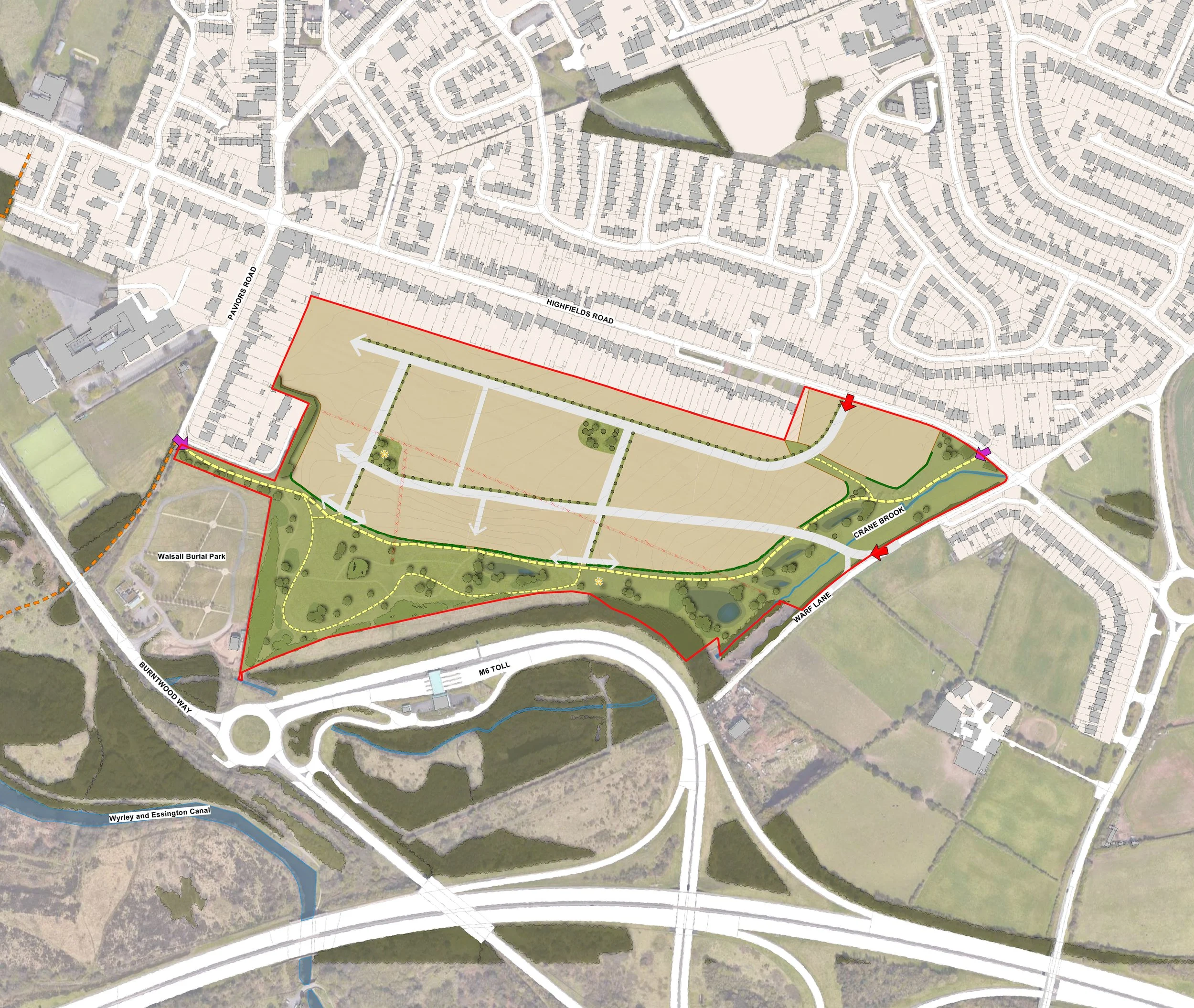
Framework Plan
Click on plan to zoom in